Search
Close this search box.
Search
Close this search box.

Hyperspectral Remote Sensing Workshop at Taylor Geospatial Institute in St. Louis

Headwall hosted a hyperspectral remote sensing workshop at the Taylor Geospatial Institute in St. Louis with presentations on mission planning and execution, as well as on applications such as precision agriculture, environmental monitoring, and water quality. It also featured an outdoor demo flight. 
Headwall Remote Sensing Program Manager John Margeson speaking at the Headwall Remote Sensing Workshop at the Taylor Geospatial Institute in St. Louis, Missouri
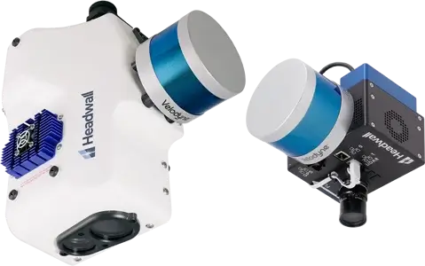
Co-Aligned HP and Nano HP payloads shown not attached to a drone

Headwall hosted an in-person Headwall hyperspectral remote sensing workshop at Taylor Geospatial Institute in St. Louis, Missouri. There were presentations on mission planning and execution, as well as on applications such as environmental monitoring and mining. There was also an outdoor demo flight.

Getting ready for the demonstration flight of the DJI M300 with Nano HP hyperspectral sensor with LiDAR at the Headwall Remote Sensing Workshop at the Taylor Geospatial Institute in St. Louis, Missouri, 2023
Headwall Program Manager for Remote Sensing, John Margeson and Applications Scientist George Killian preparing for the demonstration flight of the DJI M300 with Nano HP hyperspectral sensor with LiDAR at the Headwall Remote Sensing Workshop at the Taylor Geospatial Institute in St. Louis, Missouri, 2023

Harmful Algal Blooms Monitoring Presentation

Included in the agenda was a presentation on Headwall’s ongoing project monitoring harmful algal bloom activity in local Santuit Pond in Mashpee, Massachusetts on Cape Cod. There were customer presentations on their research and Headwall sessions on hyperspectral technology and our latest products for researchers who desire the highest performance in small, lightweight, and power-efficient packages.

Headwall Lead Pilot Charlie Keppler controls a DJI M600 drone carrying the Nano HP Hyperspectral Sensor with LiDAR as it takes off